|
Belfast is the capital City of Northern Ireland,
second largest City on the Island of Ireland, after
Dublin. Belfast grew with industries such as Linen,
Tobacco, Rope Making, and Shipbuilding. From the
early 1900s to the 1960s, the City's largest
Shipbuilders, Harland and Wolff, were one of the
largest Shipbuilders in the world. They built record
breaking Liners such as the Titanic, and Warships for
the two World Wars such as the Aircraft Carrier
HMS Formidable.
The currency in Northern Ireland is the British
Pound. Beer prices. Currency Converter.
Flight times between UK Airports and Belfast are
about 45 minutes.
George Best Belfast
City Airport is 4 miles east of Belfast centre with
inexpensive buses running between the Airport and
City centre.Map . Airlines List.
Belfast International
Airport is 20 miles northwest of Belfast.
Map . Airlines List.
There are regular ferries that run between Belfast
and Scotland, England and the Isle of Man. Ferry
Information.
|
|
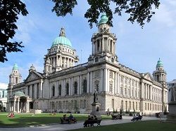
Belfast City Hall,
in the centre of Belfast, was built to
celebrate Belfast being classed as a City in
1888, designed by Sir Alfred Brumwell Thomas,
completed in 1906 for £369,000.
Large Image
by David Stanley
|
|
|
Inexpensive tours of the City Hall operate
from Monday to Saturday.
The main shopping areas of Donegall Place
and Royal Avenue lead from the City Hall.
Castle Court,
Victoria Square
and the High Street, are only a few hundred
yards north.
Map . Wiki . Bus Tours
|
|
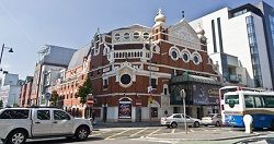
The Grand Opera
House is situated on Great
Victoria Street, 0.2 of a mile
southwest of the City Hall.
Wiki .
Website .
Map
|
|
|
Regular Grand Opera House performances take
place throughout the week.
Behind the scenes tours of the Grand Opera
House take place each Sunday at 11am, 12noon
and 1pm (performances permitting).
|
|
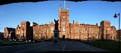
Queen's University
Belfast is 0.8 of a mile south
of the City Hall, off University
Road.
Large
Image by Jennifer Boyer
Wiki .
Website .
Map
|
|
|
The present University was originally built
as the Queen's College/ Belfast in 1849. Its
main Building, the Lanyon Building, was
designed by the architect, Sir Charles Lanyon.
The Irish Universities Act of 1908, led to the
name being changed to Queen's University
Belfast.
Queen's University Campus is open to the
public, including a Visitor's Centre. Tours are
also available by arrangement.
The area around the University is also well
worth a visit, as it contains a Park, Botanic
Garden, and the Ulster Museum.
|
|
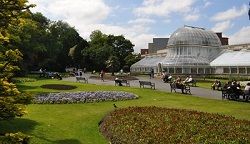
The Botanic
Gardens are 1.3 miles south of
the City centre off Stranmills Road,
next to Queens University.
Large
Image by horslips5
Wiki .
Map &
Reviews
|
|
|
The Gardens main attraction is the Palm
House. The foundation stone was laid by the
Marquess of Donegall in 1839.
The Gardens were completed in 1828, as the
private Royal Belfast Botanical Gardens. They
were only opened to the Public on Sundays,
until the Belfast Corporation bought the
Gardens in 1895, so they could be visited any
day by the Public.
|
|
The Ulster
Museum is next to the Botanic
Gardens on Landseer Street, 1.4 miles
south of the City Hall.
Wiki .
Website
. Map
|
|
|
The Museum is open from Tuesday to Sunday
from 10am - 5pm.
Exhibits are Dinosaurs, Egyptian Artifacts,
Treasure recovered from Spanish Armada Ships
sunk along the Irish coast, and 20th Century
Engineering, including information on the Liner
Titanic that was built at the Belfast
Shipbuilders, Harland & Wolff.
|
|
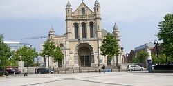
The Cathedral is built on the site of St
Anne’s Church (Belfast’s first
Church of Ireland). The foundation stone
was laid by the Countess of Shaftesbury in
1899. The West Front, as seen in the photo
above, was completed in 1927.
The North Transept was completed in 1981,
and 130 foot Spire of Hope
added in 2007. The Cathedral is open to
visitors from 10.00 am to 4.00 pm on weekdays,
and for a short period before and after
services on Sunday.
|
|
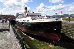
The Titanic
Quarter is next to the Odyssey
Arena, 1 mile southeast of the City
Hall, on the East side of the River
Lagan/ Port of Belfast.
Large
Image by Reading Tom
|
|
|
Harland and Wolff sold off the area or their
Yard known as the Titanic Quarter. This area
was developed into luxury Apartments and
Business Premises.
There are two landscaped areas for leisure
in the shape of two large Ships. These are said
to be the exact size, and situated exactly
where the Olympic and Titanic were built.
The ship seen above is the SS Nomadic, built
to serve as a Tender carrying passengers from
Cherbourg out to the Titanic and her Sister
Ships. She is often referred to as
Titanic’s little sister. This ship
actually carried Passengers to the Titanic on
the fateful voyage. She is the only remaining
historic link to Titanic still afloat, and,
last surviving White Star Line vessel in the
world.
The Nomadic was probably saved from the
Scrap Yards, after being bought to serve as a
Restaurant and Function Venue, moored in Paris
from 1977 - 2002.
After a successful bid at auction by the
Department for Social Development, 15th July
2006, Nomadic arrived back home in Belfast for
the first time since being built 1910 - 1911,
back in her birthplace after an absence of 95
years, 1 month and 19 days.
She now serves as a Museum next to the large
Odyssey Arena, multiplex, just a few hundred
yards up river from the Titanic Slip.
Restoration work in 2011 and 2012 saw her
uper decks and funnel restored.
The area now has the Titanic Belfast visitor
centre for information and big screen movies of
the famous ship.
Website .
Wiki . Titanic Quarter
titanicbelfast.com . Map &
Reviews
|
|
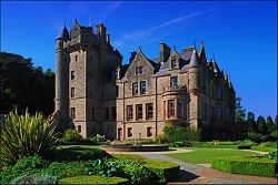
Belfast
Castle is 4 miles north of the
City Hall, high on a hillside in Cave
Hill Country Park.
Large
Image by Andrew Hurley
Wiki .
Map &
Reviews
|
|
|
This Castle was built for the 3rd Marquis of
Donegall in the 1870s. The recently restored
Belfast Castle has been open to the public free
of charge since 11th November 1988.
The Cave Hill Visitor Centre is on the
second floor of Belfast Castle. Opening hours
are 09.00 - 20.00 Monday - Saturday and 09.00 -
18.00 Sundays. Taxis are the best way to visit
the Castle, or a long walk.
Belfast Zoo is
also in Cave Hill Country Park, in an area with
bus links to the city
centre
Map/Reviews
|
|
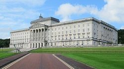
Stormont Castle
& Stormont Parliament
Buildings are 4 miles east of
Belfast centre.
Large
Image by David Stanley
Wiki .
Website
. Map
|
|
|
The Castle was built in the 1850s for John
Cleland (Rector of Newtownwards/County
Down).
The Parliament Buildings were built after
the Castle and Estate were acquired by the
Government in 1921. Both Buildings at Stormont
are now used by the Government. The surrounding
Park with Kids Play area is open to the
Public.
The Parliament Buildings are open to the
Public between 9.00am and 4.00pm Monday to
Friday.
There are regular inexpensive Buses to Stormont from the City
centre, and some Tour Buses visit.
|
|
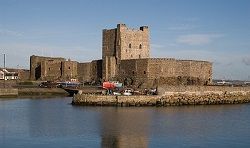
Carrickfergus
Castle, said to be the most
impressive Norman structure in Ireland,
is in the town of Carrickfergus, 12
miles northeast of Belfast centre.
Large
Image by Richard Luney
|
|
|
There are regular Buses and Trains from Belfast
to the Town of Carrickfergus. The Town itself
has some interesting attractions such as
Marina, Museum, Wildlife along its shores, and
a traditional Irish Cottage from the 1750s.
Website .
Map
|
|
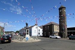
Bushmills is
a scenic Village on the north coast in
County Antrim, 59 miles north of
Belfast.
Large
Image by Reading Tom
Wiki .
Distillery . Map
|
|
|
The Village name comes from the River Bush,
and a large Watermill that was operated there
from the early 1600s.
The top Visitor Attraction in the Village is
the Old Bushmills Distillery, founded in 1608.
This is said to be the oldest Licensed
Distillery in the World. The Distillery range
includes the Bushmills Original, and Black Bush
blends. Also, the 10, 12, 16, and 21 year old
Bushmills Single Malts.
There is also an Historic Train
link between Bushmills and the Giant's
Causeway, about 4 miles north.
Bushmills
Hotels
|
|
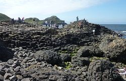
The Giant's Causeway is famous for its
Polygonal Columns of layered Basalt created
from a Volcanic Eruption 60 million years ago.
This is the only World Heritage Site in
Northern Ireland.
The Causeway Hotel
is perfectly situated for exploring the
area.
|
|
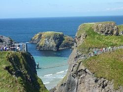
The area has a coastal Car Park with a
Footpath, about 1 mile long, leading to
Carrick-a-Rede Rope Bridge.
The Carrick-a-Rede Rope Bridge was originaly
erected by Fishermen to reach Carrick-a-Rede
Island, to check their Salmon Nets. The Bridge
is now a major tourist attraction, with
visitors testing their nerve on the
crossing.
Carrick Island has a diverse Bird life, and
great views across to Rathlin Island, and
Scotland.
The only way off the Island, is back across
the Swinging Bridge, 90 feet above the Sea.
|
|
For more information on Buses in the area,
contact Ulsterbus site: translink.co.uk
|
|
|

