|
Blencathra Hike from Threlkeld village in
the Lake District of England.
Height: 2,848ft / 868m
Blencathra is a good looking mountian for
hiking next to the A66 road that runs between
Penrith and Keswick, sitting high above the
village of Threlkeld. The image below is from
the Threlkeld Mining
Museum, looking north to the A66,
Threlkeld village, and Blencathra
Mountain.
There are six main routes to hike
Blencathra, the two steadiest routes are from
the west and east, as seen left and right in
the image below.
The three ridges in the middle are steeper
and a little dangerous. The ridge round the
back named Sharp Edge on the north side is
really dangerous.
There are three car parks for hiking, the
one on the far left is up on the mountain
side with the single lane Blease Road leading
up to it from the centre of Threlkeld.
The car park on the top side of Threlkeld,
just up round from the Horse & Farrier
Inn, also on Blease Road, has a scenic
woodland path out onto the mountain, from
where you can choose from four routes to
Blencathra summit.
The car parks to the east, right in the
image below, are at the White Horse
Inn. One car park is a large layby across
the road from the Inn, one is the Inn car
park that should only be used if you are
using the inn for drinks and snacks after the
hike, and there is another car park about one
third of a mile up the hill road next to the
White Horse Inn.
The car parks by the White Horse Inn are
used for hiking up the steady east side
Scales Fell, and the dangerous Sharp Edge
round on the north side. Only hike Sharp Edge
if you have a head for heights, and like a
fair amount of danger. Sharp Edge
Photos.
The large image is 2963 pixels wide, so
you will have to scoll sideways to view it
all.
Threlkeld Road
Map . Large Image
|

|
The image below is of the top hiking car
park on the west side of Blencathra, up past
the Horse & Farrier Inn in Thelkeld,
follow the signs for Blease Road and
Blencathra.
The car park here is about 900ft above sea
level, so about 1900ft to the summit. That is
the trail leading from the car park that
winds back to the left and up the west
side.
|

|
The image below is from the other car park
on Blease Road, a few hundred yards up round
from the Horse & Farrier Inn in
Threlkeld, about 600ft above sea level.
The woodland path from this car park, as
seen below, is scenic with a wooden bridge
across the burn. The top of the woodland path
gives you a number of routes onto the
mountain, or walks along the bottom of the
mountian.
|

|
The image below is from the top of the
woodland path from the car park in Threlkeld.
One trail from here leads round to the left,
and up the steady and safe route to
Blencathra summit from the west.
The trail straight ahead leads up and to
the right for the steeper Gategill Fell, with
an interesting ridge at the top.
|

|
The image below is from the top of the
woodland path, looking east to the path along
the bottom of Blencathra. This path keeps you
away from Gategill Farm, that is a busy
working farm. Halls Fell is just along there
about half of a mile, and Doddick Fell about
another half mile beyond that.
Halls and Doddick have the most
adventurous looking routes to the top from
this side, with narrow ridges to follow close
to the top.
|

|
The image below is from where the trail
along the bottom of Blencathra reaches Halls
Fell. That is the highest point on Blencathra
up there, and there is a knife edge ridge
leading straigh to it from this fell. If you
are going to Doddick Fell, just follow the
good path along the bottom here for about
another half mile.
This is a really steep route, and these
two men have just run down it.
|

|
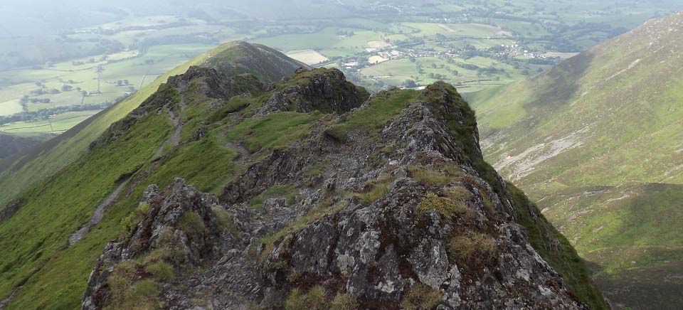
The image below is of Halls Fell Ridge,
leading to the highest point on Blencathra.
That is the Doddick Fell Ridge over to the
right, another interesting route up.
There is a trail all the way along the top
of this ridge for the adventurous, and
another trail most of the way just down from
the top. The lower trail has a few spots
where it is narrow and right over high drops,
so is a little dangerous as well.
I got to a rock pinnacle about 200ft from
the top, in real thick cloud. You either have
to climb straight over the pinnacle, or
follow a faint trail down to the left and
back up beyond the pinnacle. I hung around
for the cloud to clear, but it looked like it
could have been hours, so decided to head
back down. The image below was taken on the
road back down, when the cloud lifted for a
couple of minutes.
I met a hiker going up that stated the
route to the left of the pinnacle is fairly
safe, then it is just a short, steep hike
from there to the summit.
I mainly hike to get sunny images, so
getting to the top in thick cloud is not much
use to me. I will return. It was my last day,
so only had three hours to get up and back
down.
|

|
The image below is from Halls Fell Ridge,
looking west across to Getegill Ridge. Now
that looks another interesting route up.
|

|
The image below is looking back down Halls
Fell Ridge. I was staying at Doddick Farm
Holiday Cottages at the bottom of Doddick and
Halls Fells, and each morning while walking
the dog, I looked up at this ridge thinking,
I just have to get up there one day for some
photos.
|
|
The image below is from the bottom of
Halls Fell Ridge looking down the main path.
This is a fairly steep hike all the way up to
this point. You can see the path leading
along the bottom of the mountain, and the
woodland path down to the car park.
Large
Image
|

|
This is an interesting mountain with a
number of good looking routes to the top,
need to try a different one ech time I am in
the area. The walk along the bottom is
interesting as well.
The Horse & Farriers Inn, and White
Horse Inn, are ideally situated for drinks
and meals, also for accommodation, I liked
both.
Make sure and take an Ordnance Survey Map
and Compass on these hikes, and know how to
use them, as in cloud, these mountains can be
deadly. In Winter, make sure you have
Crampons and an Ice Axe, and know how to use
them.
|
|